如何用python获取到照片拍摄时的详细位置(附源码)
目录
- 一.引言
- 1.读取照片信息,获取坐标
- 2.通过baidu Map的API将GPS信息转换成地址。
- 二.源码附上!!!
- 注意事项
- 总结
一.引言
先看获取到的效果
拍摄时间:2021:12:18 16:22:13
照片拍摄地址:('内蒙古自治区包头市昆都仑区', '内蒙古自治区', '包头市', '昆都仑区', '多米幼儿园东南360米')

我们的女朋友给我们发来一张照片我们如何获取到她的位置呢?
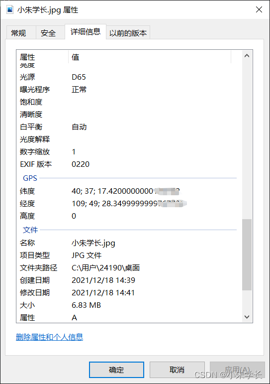
用手机拍照会带着GPS信息,原来没注意过这个,因此查看下并使用代码获取照片里的GPS信息
查看图片文件属性

1.读取照片信息,获取坐标
ExifRead
Python library to extract EXIF data from tiff and jpeg files.
安装
pip install exifread
读取GPS
import exifread
import re

def read():
    GPS = {}
    date = ''
    f = open("C:\\Users\\24190\\Desktop\\小朱学长.jpg",'rb')
    contents = exifread.process_file(f)
    for key in contents:
        if key == "GPS GPSLongitude":
            print("经度 =", contents[key],contents['GPS GPSLatitudeRef'])
        elif key =="GPS GPSLatitude":
            print("纬度 =",contents[key],contents['GPS GPSLongitudeRef'])
        #print(contents)
read()
运行

我们得到了一个简易的gps地址
如果想要读取全部的拍摄信息:
# 读取照片的GPS经纬度信息
def find_GPS_image(pic_path):
        GPS = {}
        date = ''
        with open(pic_path, 'rb') as f:
                tags = exifread.process_file(f)
                for tag, value in tags.items():
                        # 纬度
                        if re.match('GPS GPSLatitudeRef', tag):
                                GPS['GPSLatitudeRef'] = str(value)
                        # 经度
                        elif re.match('GPS GPSLongitudeRef', tag):
                                GPS['GPSLongitudeRef'] = str(value)
                        # 海拔
                        elif re.match('GPS GPSAltitudeRef', tag):
                                GPS['GPSAltitudeRef'] = str(value)
                        elif re.match('GPS GPSLatitude', tag):
                                try:
                                        match_result = re.match('\[(\w*),(\w*),(\w.*)/(\w.*)\]', str(value)).groups()
                                        GPS['GPSLatitude'] = int(match_result[0]), int(match_result[1]), int(match_result[2])
                                except:
                                        deg, min, sec = [x.replace(' ', '') for x in str(value)[1:-1].split(',')]
                                        GPS['GPSLatitude'] = latitude_and_longitude_convert_to_decimal_system(deg, min, sec)
                        elif re.match('GPS GPSLongitude', tag):
                                try:
                                        match_result = re.match('\[(\w*),(\w*),(\w.*)/(\w.*)\]', str(value)).groups()
                                        GPS['GPSLongitude'] = int(match_result[0]), int(match_result[1]), int(match_result[2])
                                except:
                                        deg, min, sec = [x.replace(' ', '') for x in str(value)[1:-1].split(',')]
                                        GPS['GPSLongitude'] = latitude_and_longitude_convert_to_decimal_system(deg, min, sec)
                        elif re.match('GPS GPSAltitude', tag):
                                GPS['GPSAltitude'] = str(value)
                        elif re.match('.*Date.*', tag):
                                date = str(value)
        return {'GPS_information': GPS, 'date_information': date}
2.通过baidu Map的API将GPS信息转换成地址。
众所周知gps和百度的经纬度会有误差,那么我们需要调用百度转换接口,这个百度目前没有开源。
# 通过baidu Map的API将GPS信息转换成地址。
def find_address_from_GPS(GPS):
        """
        使用Geocoding API把经纬度坐标转换为结构化地址。
        :param GPS:
        :return:
        """
        secret_k ey = 'XXX'
        if not GPS['GPS_information']:
                return '该照片无GPS信息'
        lat, lng = GPS['GPS_information']['GPSLatitude'], GPS['GPS_information']['GPSLongitude']
        baidu_map_api = "http://api.map.baidu.com/geocoder/v2/?ak={0}&callback=renderReverse&location={1},{2}s&output=json&pois=0".format(
                secret_key, lat, lng)
        response = requests.get(baidu_map_api)
        content = response.text.replace("renderReverse&&renderReverse(", "")[:-1]
        print(content)
        baidu_map_address = json.loads(content)
        formatted_address = baidu_map_address["result"]["formatted_address"]
        province = baidu_map_address["result"]["addressComponent"]["province"]
        city = baidu_map_address["result"]["addressComponent"]["city"]
        district = baidu_map_address["result"]["addressComponent"]["district"]
        location = baidu_map_address["result"]["sematic_description"]
        return formatted_address, province, city, district, location
然后在主函数输出:

二.源码附上!!!
# coding=utf-8
import exifread
import re
import json
import requests
import os

# 转换经纬度格式
def latitude_and_longitude_convert_to_decimal_system(*arg):
        """
        经纬度转为小数, param arg:
        :return: 十进制小数
        """
        return float(arg[0]) + ((float(arg[1]) + (float(arg[2].split('/')[0]) / float(arg[2].split('/')[-1]) / 60)) / 60)

# 读取照片的GPS经纬度信息
def find_GPS_image(pic_path):
        GPS = {}
        date = ''
        with open(pic_path, 'rb') as f:
                tags = exifread.process_file(f)
                for tag, value in tags.items():
                        # 纬度
                        if re.match('GPS GPSLatitudeRef', tag):
                                GPS['GPSLatitudeRef'] = str(value)
                        # 经度
                        elif re.match('GPS GPSLongitudeRef', tag):
                                GPS['GPSLongitudeRef'] = str(value)
                        # 海拔
                        elif re.match('GPS GPSAltitudeRef', tag):
                                GPS['GPSAltitudeRef'] = str(value)
                        elif re.match('GPS GPSLatitude', tag):
                                try:
                                        match_result = re.match('\[(\w*),(\w*),(\w.*)/(\w.*)\]', str(value)).groups()
                                        GPS['GPSLatitude'] = int(match_result[0]), int(match_result[1]), int(match_result[2])
                                except:
                                        deg, min, sec = [x.replace(' ', '') for x in str(value)[1:-1].split(',')]
                                        GPS['GPSLatitude'] = latitude_and_longitude_convert_to_decimal_system(deg, min, sec)
                        elif re.match('GPS GPSLongitude', tag):
                                try:
                                        match_result = re.match('\[(\w*),(\w*),(\w.*)/(\w.*)\]', str(value)).groups()
                                        GPS['GPSLongitude'] = int(match_result[0]), int(match_result[1]), int(match_result[2])
                                except:
                                        deg, min, sec = [x.replace(' ', '') for x in str(value)[1:-1].split(',')]
                                        GPS['GPSLongitude'] = latitude_and_longitude_convert_to_decimal_system(deg, min, sec)
                        elif re.match('GPS GPSAltitude', tag):
                                GPS['GPSAltitude'] = str(value)
                        elif re.match('.*Date.*', tag):
                                date = str(value)
        return {'GPS_information': GPS, 'date_information': date}

# 通过baidu Map的API将GPS信息转换成地址。
def find_address_from_GPS(GPS):
        """
        使用Geocoding API把经纬度坐标转换为结构化地址。
        :param GPS:
        :return:
        """
        secret_ke y = 'zbLsuDDL4CS2U0M4KezOZZbGUY9iWtVf'
        if not GPS['GPS_information']:
                return '该照片无GPS信息'
        lat, lng = GPS['GPS_information']['GPSLatitude'], GPS['GPS_information']['GPSLongitude']
        baidu_map_api = "http://api.map.baidu.com/geocoder/v2/?ak={0}&callback=renderReverse&location={1},{2}s&output=json&pois=0".format(
                secret_key, lat, lng)
        response = requests.get(baidu_map_api)
        content = response.text.replace("renderReverse&&renderReverse(", "")[:-1]
        print(content)
        baidu_map_address = json.loads(content)
        formatted_address = baidu_map_address["result"]["formatted_address"]
        province = baidu_map_address["result"]["addressComponent"]["province"]
        city = baidu_map_address["result"]["addressComponent"]["city"]
        district = baidu_map_address["result"]["addressComponent"]["district"]
        location = baidu_map_address["result"]["sematic_description"]
        return formatted_address, province, city, district, location

if __name__ == '__main__':
        GPS_info = find_GPS_image(pic_path='小朱学长.jpg')
        address = find_address_from_GPS(GPS=GPS_info)
        print("拍摄时间:" + GPS_info.get("date_information"))
        print('照片拍摄地址:' + str(address))
注意事项
1.照片的地址信息等,一般的手机相机默认是打开的。
2.微信和QQ里面发送原图,信息都会完整的保留下来。
3.代码里面需要处理在照片我放到了代码的同文件夹下,所以没有写路径,大家可以自己写路径,或者放到于代码相同的路径下即可。
总结
到此这篇关于如何用python获取到照片拍摄时的详细位置的文章就介绍到这了,更多相关python获取照片详细位置内容请搜索我们以前的文章或继续浏览下面的相关文章希望大家以后多多支持我们!
赞 (0)

